Soil moisture probes - What difference can they make to decision marking in dryland cropping?
Author: Dale Boyd | Date: 06 Feb 2013
Dale Boyd
Department of Primary Industries, Victoria
Take home messages
- Under a scenario of greater climate variability, rainfall may decrease and its distribution across the year will change. This change will increase the importance of input decisions based on a sound estimate of water limited yield potential.
- Soil moisture probes like any other component of precision ag can help people confirm decisions or take decision making to another level.
- Management decisions determining crop type, inputs such as nutrition and disease control are the ones identified where knowledge of deep soil moisture levels may assist with risk management.
- DPI is working on a project with farmers and service providers to determine the best use of this technology.
- Biggest learning to date – amount of moisture that a crop can deplete in spring conditions and the importance of a significant rain during this time.
In dry land cropping, soil moisture is often the greatest limiting resource for crop production in Australia. While cropping farmers have always had to manage seasonal variability, under a scenario of greater climate variability, rainfall may decrease and its distribution across the year will change. This change will increase the importance of input decisions based on a sound estimate of water limiting yield potential.
This knowledge can assist to manage risk but the real time data of soil moisture levels is just one piece of information. Knowledge is critical for farmers to make strategic decisions and grow the appropriate crop (type, inputs) for the season to maximise water use efficiencies. Presently ‘very interesting graphs’ can be produced that map changes of sub soil moisture but a current DPI project titled ‘Risk Management through soil moisture monitoring’ is aiming to take this further. The objective is to demonstrate the capability of soil moisture monitoring technology with remote communication systems to display soil moisture data from key cropping regions across Victoria and determine how this information can be used by both agronomist and farmers.
Background
Soil moisture probes have been successfully implemented in irrigation environments to assist in scheduling irrigation events and a greater adoption of this technology is likely with improved service delivery of water and significant investment on-farm of irrigation infrastructure.
There are limited examples of the use of soil moisture probes in a dryland cropping system but there is an increasing interest in the farming sector from both service providers and farmer groups.
A 2011 GRDC national farmer survey, reported an increase in the percentage of the crop where soil moisture is being assessed through the crop period in Victoria since the previous survey in 2009. In-crop soil-moisture monitoring has grown in all cropping areas.
A scoping study has also been conducted on the focus groups of farmers involved in the projects nine monitoring sites and found that:
Soil moisture levels are estimated/measured by over 90% of the group and conducted by a number of methods, generally subjective. Most popular were estimations from recent rainfall events, crop condition, and drive by observations. Some were using self calibrated tools such as push probes and soil sampling and determining the wetness of soil. General feeling was that estimations could be improved on current methods and there were enough cases where they had got it wrong to explore alternatives.
Agronomists generally had a greater interest in soil moisture monitoring technology as a need to measure, when advising on critical business decisions. Benefits were identified with time efficient monitoring and the ability to compare previous year’s data. There were a very small percentage of farmers who were using volumetric sampling where millimetres of water could be calculated with some farmers taking these measurements and entering them into a modelling program. The use of the modelling program Yield ProphetTM will be discussed as part of this session.
Being a state-wide project across many rainfall districts and soil types there are some differences identified with use of probes by the groups of farmers.
In low rainfall areas, using soil moisture probes may aid the crop choice decision making guided by pre sowing plant available water and also the time of sowing where good soil moisture reserves gives confidence to sow by the calendar. Higher rainfall zones with reliable winter rainfall, farmers will follow rotations as guided by Best Management Practices and not by soil moisture reserves but knowing the soil moisture levels will allow strategic inputs through the growing season to target the potential high yields.
Over the three seasons of monitoring, the project will build up knowledge of crop upper and lower limits under different soil and crop types. The two seasons so far have been quite remarkable with at least one wet summer (some sites with two and floods). The growing seasons have been low decile which has seen a huge draw down in soil moisture through the months of late August to October. The value of sub-soil moisture has been clearly evident and most people involved have been amazed as to the ability of crops to use moisture from 60cm and beyond and how quickly a large biomass crop will use moisture with increasing day length and temperature (and limited rain).
The following are examples of where this information could be used to assist in decision making in dryland cropping.
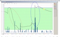
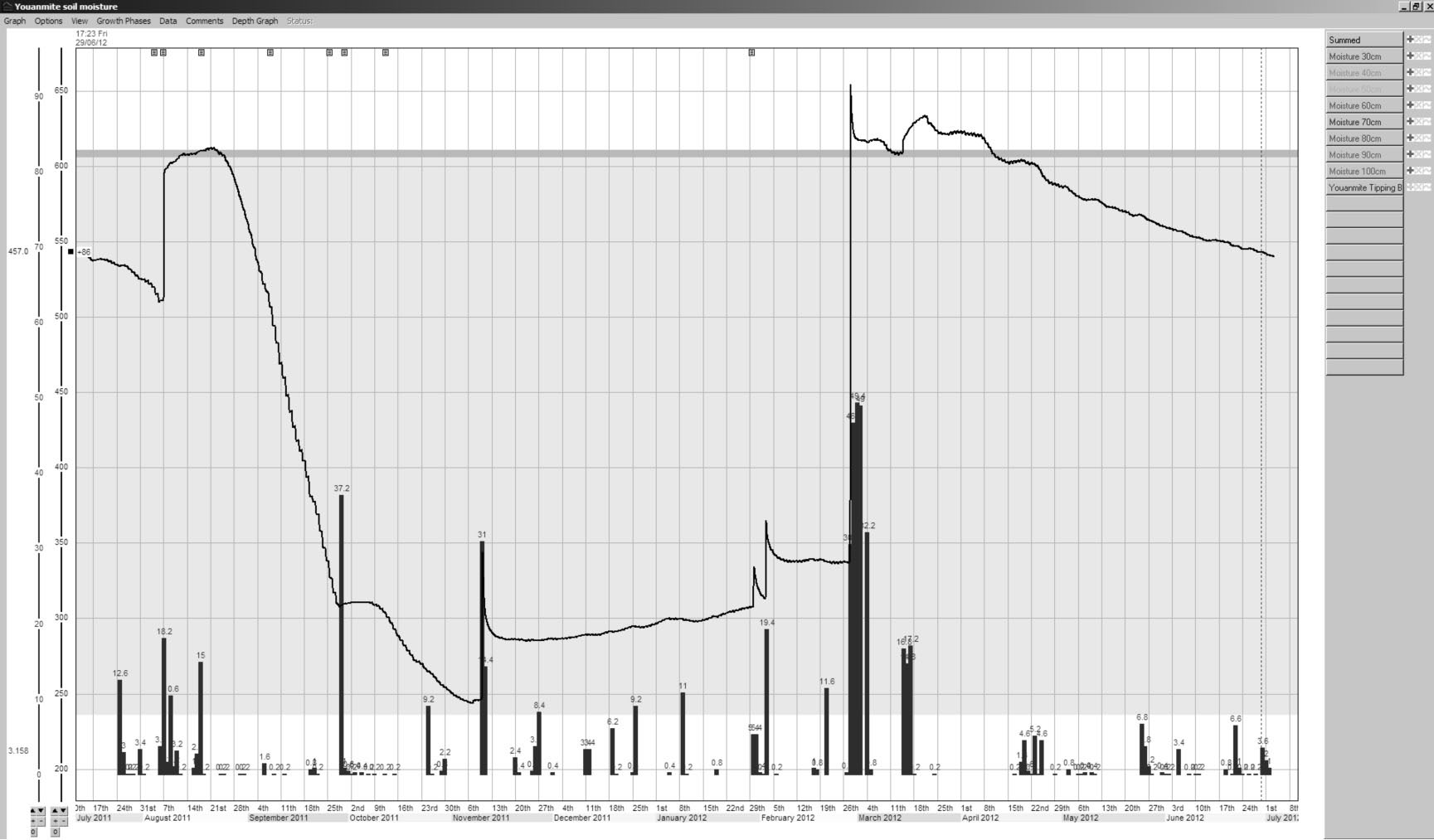
Figure 1. Accumulation of soil moisture through summer and Autumn from a dry soil profile
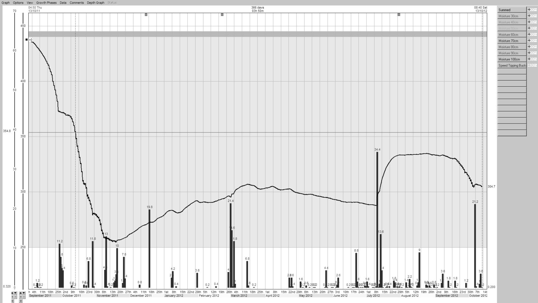
Figure 1 represents data recorded at the Youanmite (North East Victoria) site. Dotted oval indicates the depletion of soil moisture reserves through spring 2011 and the dashed oval represents the flooding rains at the site in early March 2012 that refilled the profile. The star indicates the sowing time where the crop was planted with a good profile of deep moisture. The shaded area is where plant moisture use has been observed, and the white area below is nearing crop lower limit and moisture stress. The black line is a summed total of soil water content.
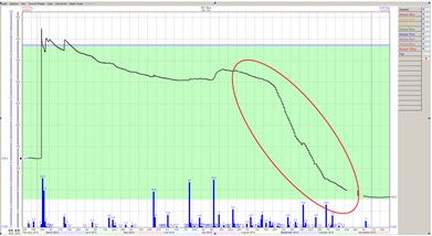
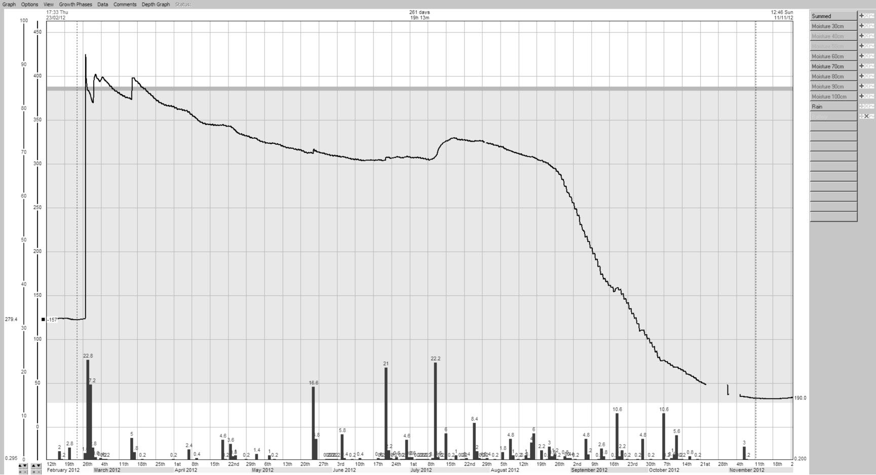
Figure 2. Plant water use through spring with high levels of plant available water
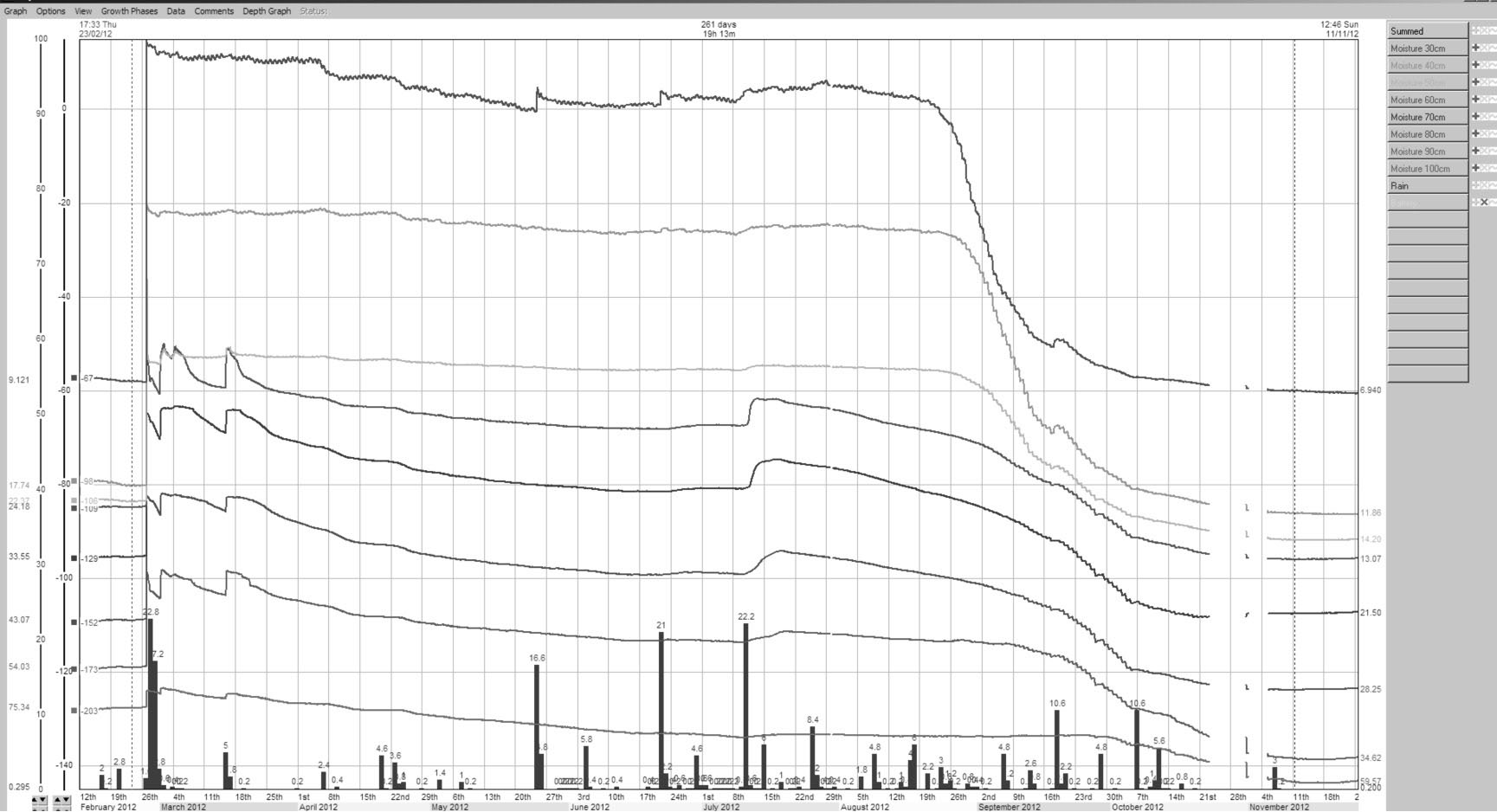
Figure 2 represents data recorded at the Raywood (Central Victoria) site. The oval highlights the depletion of a near full profile of moisture recorded in July with a low decile spring. The level recorded at mid November is now a crop lower limit for that monitored soil type.
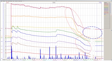
Figure 3. A zoomed view of the Raywood site of all the individual sensor depths
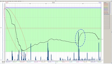
Figure 3 represents a zoomed view of all the individual sensor depths (positioned every 10cm starting at 30cm to 100cm). Dotted ovals highlight the moisture use from the different soil depths. Early spring it is from the easiest source point being the shallow sensors while in late September moisture is being used from 60cm down to a meter. The dashed oval indicates that the sensors at that depth have reached crop lower limit with no change in the soil water content (flat line) during October. At this site with the dry spring, crop lower limit was reached down to one meter. (NB. separate sensor graphs are defined by colour which is not available in this document so the sensor lines are arranged as per depth location, shallowest on top and deepest on the bottom).
Figure 4 represents the summed soil moisture content from site at Speed (Mallee). The dotted oval highlights the depletion of a full profile of moisture in 2011 with a low decile spring. The soil moisture reserves were never built up to those levels again even after considerable rain in July deposited moisture deep (dashed oval). Low moisture use in spring 2012 was attributed to crop vigour and limited plant available moisture.
Summary
The challenge to the grains sector is to increase productivity growth. This may be from a number of options, some of which include:
- Better farm decisions through improved information - not just more information
- Potentially through the uptake of new technology.
Soil moisture monitoring has the potential to successfully link to both of these and will be further evaluated during the period of the project.
Challenge – Micro monitoring site for paddock size management. Different soil types across paddock and farm and how many sites required V’s the ability to vary paddock management.
Contact details
Dale Boyd
PO Box 441, Echuca 3564
(03) 5482 0439
Dale.Boyd@dpi.vic.gov.au
Was this page helpful?
YOUR FEEDBACK